
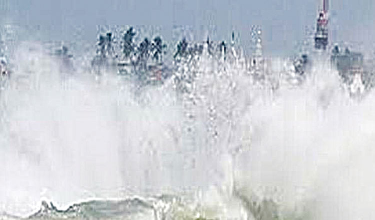
Chennai, Dec 8 (Representative) The Cyclonic Storm “Mandous” pronounced as “ManDous” over the Southwest Bay of Bengal, has been moving towards the North TamilNadu coast andit would cross the coast between Puducherry and Sriharikota tomorrow midnight. Met office sources today said the Cyclonic Storm is now lay centred about 300 km east-northeast of Trincomalee (Sri Lanka), 420 km east-southeastof Jaffna (Sri Lanka), 460 km east-southeast of Karaikal and about 550 km southeast of Chennai. It is very likely to move west-northwestwards and cross the north Tamil Nadu, Puducherry and adjoining south Andhra Pradesh coasts between Puducherryand Sriharikota with a maximum sustained wind speed of 65-75 kmph and gusting to 85 kmph around midnight tomorrow. People of the Chennai city and suburbs have started seeing the impact of thecyclonic storm as the weather turned chill and blustery winds were blowingon and off at about 40 to 50 kmph speed since today morning, which was interspersed with slight rain and drizzles. As North Coastal districts of Tamil Nadu is expected to receive heavy to very heavy rainfall, with extremely heavy fall, the State government has put all the district administration on high alert to meet any exigency and has opened more than 5,000 relief camps in all the districts to house people evacuated fromlow lying areas. Revenue and Disaster Management Miniser KKSSR Ramachandran said12 companies of NDRF and SDRF teams, comprising 390 personnel were deployed in ten districts of the state, including in Nagapattinam, Thanjavur, Tiruvarur, Cuddalore, Mayiladuthurai, Chennai, iruvallur, Kancheepuram, Cgengalpattu and Villuppuram.
The state government control centre set up by the Revenue and Disasater Management department is continuously monitoring the situation. Met office said under the influence of the Cyclonic Storm, heavy to very heavy rain fall is likely to occur at isolated places over Cuddalore, Mayiladuthurai, Thanjavur, Tiruvarur, Nagapattinam and Pudukkottai districts of Tamil Naduand Karaikal. Heavy rain is also likely to occur at isolated places over Kancheepuram, Chengalpattu, Villupuram, Kallakurichi, Perambalur, Ariyalur, Tiruchirappalli, Sivaganga and Ramanathapuram districts of Tamil Nadu and Puducherry today. Tomorrow, heavy to very heavy rain at a few places with extremely heavy rain at one or two places will occur over Kancheepuram, Chengalpattuand Villupuram districts of Tamil Nadu and Puducherry. Heavy to very heavy rain is likely to occur at isolated places over Tiruvallur, Chennai, Ranipet, Vellore, Tirupattur, Tiruvannamalai, Kallakurichi andCuddalore districts of Tamil Nadu. Heavy rain is also likely to occur at isolated places over Dharmapuri, Salem, Namakkal, Tiruchirappalli, Perambalur, Ariyalur, Mayiladuthurai, Tiruvarur, Nagapattinam, Thanjavur, Pudukkottai, Karur, Dindigul, Madurai and Sivagangadistricts of Tamilnadu and Karaikal. The Met Office has issued a Red Code warnng for Chennai, Kancheepuram, Chengalpattu and Villuppuram districts of Tamil Nadu and for Puducherry for tomorrow and Orange Code alert for Saturday.
On December 10, hea vy to very heavy rain is likely to occur at isolated placesover Tiruvallur, Chennai, Kancheepuram, Chengalpattu, Ranipet, Vellore, Tiruvannamalai, Tirupattur, Krishnagiri and Dharmapuri districts of Tamil Nadu. Heavy rain is also likely to occur at isolated places over Villupuram, Kallakurichi, Salem, Erode and Nilgiris districts of Tamil Nadu and Puducherry. On December 11 and 12, light to moderate rain at many places with isolatedthunderstorm and lightning is likely to occur over Tamilnadu, Puducherry andKaraikal area. Strong winds with speed reaching 50-60 kmph and gusting to 70 kmph likely to prevail over northern parts of coastal Tamil Nadu, Puducherry and Karaikal from tomorrow morning. The wind speed will gradually increase to gale wind speed of the orderof 60-70 kmph and gusting to 80 kmph by the evening and continue tillDecember 10 early morning. Strong winds with speed reaching 40-50 kmph and gusting to 60 kmph islikely over southern parts of coastal Tamil Nadu. The next 48 hr forecast for Chennai City and its neighbourhood is the skycondition is likely to be generally cloudy. Heavy to very heavy rain is likelyto occur. Strong winds with speed reaching 50-60 kmph and gusting to 70 kmphis likely from tomorrow morning and the wind speed would graduallyincrease to gale wind speed of the order of 60-70 kmph and gusting to80 kmph by the evening till December 10 early morning. Fishermen were advised to stay away from sea till December 10.